


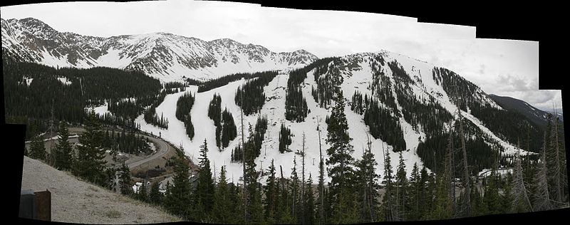
Shortened as The Basin or A-Basin, Arapahoe Basin is a ski area located in Colorado (within the White River National Forest). Known for Arapahoe Basin best trails, it enjoys the reputation of being one of the oldest alpine ski areas with short lift lines and extreme terrain.
The Basin is open up till early June—the period can sometimes get extended up till even July. Located on U.S. Highway 6, the A-Basin hugs the Continental Divide at approximately at 13,050 feet. Now read on if you’re in The Basin and you’re a tad confused as to which all are really great hiking trails here.
Grizzly Peak Trail
Details: 5 miles/vertical 1,637 feet
The mountain got its name for its looks; from appearance, it resembles a grizzly white bear. As part of the Arapahoe Basin Best Trails, this route features a beautiful ridge walk and demands a steep scramble near its end. (However, considering the breathtaking views it offers, the effort is well worth it.) The climb is strenuous, as the trail’s altitude must be regained both coming and going. Compared to Torrey Peaks and Grays, the Grizzly Peak trail is a longer trek
Baker Mountain Trail
Details: 2 miles/vertical 448 feet
This trail is a short but steep hike, which begins right from Loveland Pass’s top. This summit is way easier to achieve when it’s compared with those of the Grizzly Peak and Sniktau Mountain. You’ll start at nearly 12,000 feet, and you’ll be required to climb about 500 miles extra.
Sniktau Mountain Trail
Details: 4 miles/vertical 1,300 feet
The hike is one of the finest for all those who’ve got enough of that alpine hiking experience, but they have neither the time nor the energy to spend hours and hours hiking to just get above the tree line. This is a tad shorter hike than the others, and it’ll still give you around 1,000’ of elevation in the very first mile itself.
McCullough Gulch Trail
Details: 3.4 miles/1,100 feet
The McCullough Gulch trail is very scenic, and the reason for that is the waterfall that comes with it. As you’ll begin your trail, you’ll see a number of streams crossing your way. There are many shorter trails that, if followed, will lead you to different levels of the waterfall. However, each of these trails is a part of the major McCullough Gulch trail.
The way to reach each of these three trails from Keystone: You’ll have to take the U.S. Highway 6 and arrive at the Loveland Pass summit. You can park your ride right beside the Continental Divide sign and begin your hike.
Now, if you’re a peripatetic and you’re even planning a trip to A-Basin, you know a great deal of the area’s hiking trails. Book your ride with Fresh Tracks Transportation for affordable and reliable shuttle services.